
Freedom Trail, Boston: free self-guided walking tour
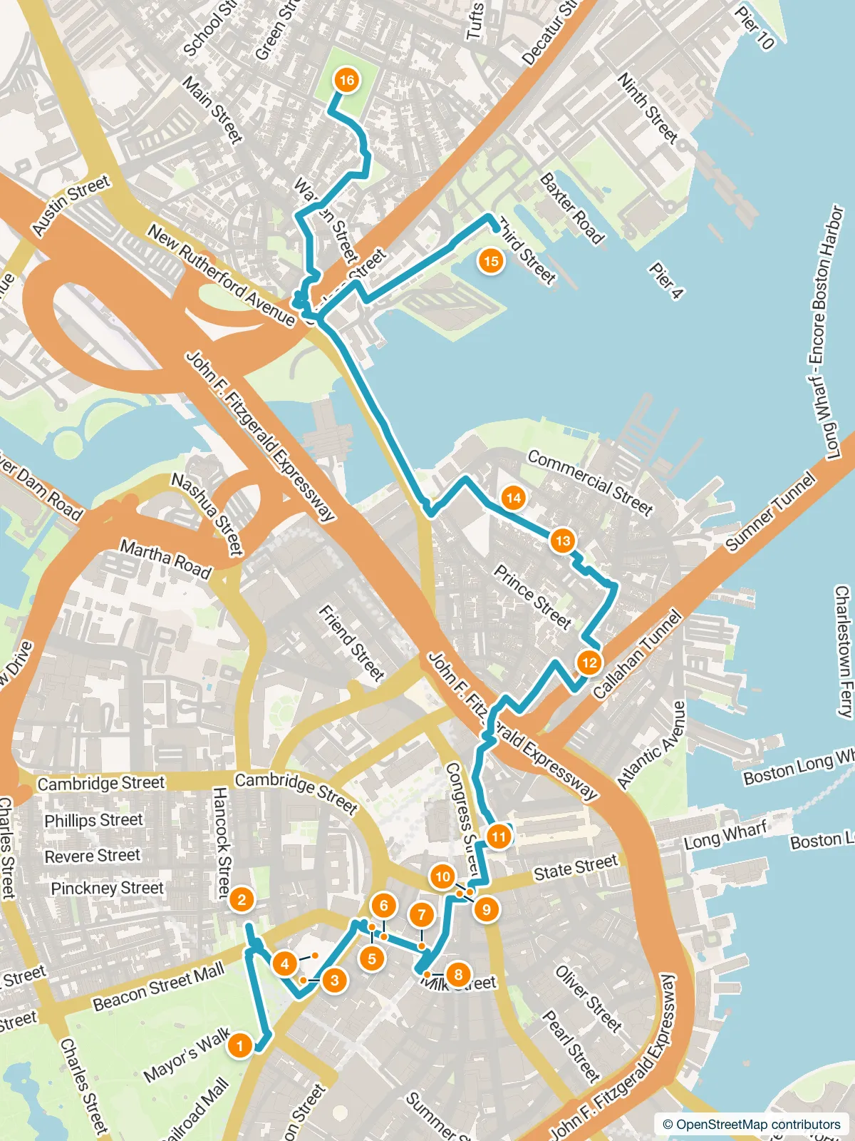
Quick answer. A free self-guided walking tour along the Freedom Trail in Boston: 16 stops, about 5.8 km, about 75 minutes of walking plus about 100 minutes of listening. It takes in all 16 official sites in The Freedom Trail Foundation’s order on one walking map, from Boston Common to the Bunker Hill Monument. The Foundation gives the trail as 2.5 miles; our mapped walk follows the red line and comes out longer, because the line loops around Faneuil Hall, runs out to the USS Constitution in the Navy Yard and back, and climbs Charlestown’s streets to the Monument. Every stop has a free audio guide, from the State House to the Old North Church.
Official route: The Freedom Trail Foundation’s 16 sites, in its order (source, read October 25, 2026). The Foundation gives the trail as 2.5 miles; our mapped walk along the red line measures about 5.8 km.
- Stops:
- 16
- Distance:
- about 5.8 km
- Walking:
- about 75 min
- Listening:
- about 100 min
Two ways to do this walk
Boston with Mappu
Walk Mode, in the free Mappu app
It knows where you are, tells you about everything you pass between the stops, answers your questions and keeps you on the route. Your phone stays in your pocket.
A 2-hour live walk, €4.99.
50 credits from the Starter pack. One-time purchase, no subscription.
Self-guided audio walk. No guide accompanies you. Not affiliated with the sites.
Free: the audio guides
Listen to each stop’s audio guide in your browser and find your own way between the stops.
Walking directions in Google MapsFreedom Trail, Boston: how long does the walk take?
About 175 minutes in all: about 75 minutes on foot over about 5.8 km, plus about 100 minutes of audio at the 16 stops. Time inside the sites is extra.
Freedom Trail, Boston: in what order should you visit the stops?
Follow the stops in this order: Boston Common, Massachusetts State House, Park Street Church, Granary Burying Ground, King’s Chapel & King’s Chapel Burying Ground, Boston Latin School Site/Benjamin Franklin Statue, Old Corner Bookstore, Old South Meeting House, Old State House, Boston Massacre Site, Faneuil Hall, Paul Revere House, Old North Church, Copp’s Hill Burying Ground, USS Constitution, and Bunker Hill Monument. The longest stretch between two stops is about 1.4 km, about 19 min on foot.
Route and map
Indicative route. While you walk, watch where you're going, mind the traffic and follow local signs and rules. The map is an aid, not a safety guide. Terms

Follow Mappu’s map: the route runs along the streets from stop to stop, and the stories keep playing as you walk.
Google Maps opens up to 5 stops at a time on a phone, so the route comes in parts: each part starts where the last one ends.
Stop 1
America’s oldest public park, held in common since 1634, where grazing cows once ruled.
about 6 min of audio
Next stop: Massachusetts State House · about 0.4 km, about 5 min on foot
Stop 2
Charles Bulfinch’s Federal masterpiece on Beacon Hill, completed in January 1798 and still the seat of the state’s government.
about 6 min of audio
Next stop: Park Street Church · about 0.3 km, about 3 min on foot
Stop 3
Its slender white steeple has risen beside Boston Common since the early nineteenth century; the congregation was founded in 1809.
about 6 min of audio
Next stop: Granary Burying Ground · about 0.1 km, about 1 min on foot
Stop 4
Where Boston’s patriots, merchants and children rest on Tremont Street, next to Park Street Church.
about 7 min of audio
Next stop: King’s Chapel & King’s Chapel Burying Ground · about 0.2 km, about 2 min on foot
Stop 5
Boston’s oldest burial ground and, beside it, King’s Chapel, a granite church in the Georgian style.
about 6 min of audio
Next stop: Boston Latin School Site/Benjamin Franklin Statue · about 0.1 km, about 1 min on foot
Stop 6
On School Street, the City Carpet mosaic marks where America’s oldest public school was founded in 1635, and a statue of Benjamin Franklin stands guard.
about 6 min of audio
Next stop: Old Corner Bookstore · about 0.1 km, about 1 min on foot
Stop 7
Boston’s oldest commercial building, and a cradle of American literature in the heart of downtown.
about 6 min of audio
Next stop: Old South Meeting House · about 0.1 km, about 1 min on foot
Stop 8
The Boston meeting house where a debate over the tax on tea became a turning point.
about 7 min of audio
Next stop: Old State House · about 0.2 km, about 3 min on foot
Stop 9
Boston’s oldest surviving public building, where a colony argued its way toward revolution.
about 6 min of audio
Next stop: Boston Massacre Site · about 0.1 km, about 1 min on foot
Stop 10
A circle of stones marks the spot where a winter night in 1770 changed a city.
about 6 min of audio
Next stop: Faneuil Hall · about 0.2 km, about 2 min on foot
Stop 11
Narrated at Faneuil Hall, built in 1742 by the merchant Peter Faneuil as both a marketplace and a meeting hall.
about 7 min of audio
Next stop: Paul Revere House · about 0.8 km, about 11 min on foot
Stop 12
A seventeenth-century home on North Square, in Boston’s North End, where Paul Revere lived.
about 6 min of audio
Next stop: Old North Church · about 0.4 km, about 6 min on foot
Stop 13
Boston’s oldest standing church, and the steeple of a famous night in 1775.
about 6 min of audio
Next stop: Copp’s Hill Burying Ground · about 0.2 km, about 2 min on foot
Stop 14
Boston’s hilltop of memory, a burial ground above the North End and the harbour.
about 7 min of audio
Next stop: USS Constitution · about 1.4 km, about 18 min on foot
Stop 15
Old Ironsides, the oldest commissioned warship still afloat, berthed at Pier One in the Charlestown Navy Yard.
about 6 min of audio
Next stop: Bunker Hill Monument · about 1.4 km, about 19 min on foot
Stop 16
A granite obelisk on Breed’s Hill in Charlestown, the last of the trail’s sixteen sites.
about 6 min of audio
The stop stories are AI-generated audio guides and can contain mistakes. Check opening hours and tickets on the official sites.
Planning a trip to Boston?
Get your plan
Mappu sketches your days free in the chat, no account needed. Then take the full plan with you:
- Weekend trip, €9.99: Your day-by-day plan plus 2 live walks
- Save your trip’s free guides on your phone in the Mappu app: they play with no signal
Before you go
- Check opening hours, tickets and access on each site’s official page before you go.
- Distances and times are estimates: the walking route between stops, from OpenStreetMap, at 4.5 km/h. Your route on the street may differ.
Useful for your visit
Tickets, tours and practical extras for this trip, from Mappu's partners.
- Freedom Trail Boston: guided tourViator · Partner(opens the partner's site in a new tab)
- USS Constitution and more: guided tourViator · Partner(opens the partner's site in a new tab)
- Freedom Trail Boston: self-guided audio tourViator · Partner(opens the partner's site in a new tab)
Partner links (Airalo, Amazon, Booking.com, GetYourGuide, Klook, Tiqets, Trip.com, Viator, Welcome Pickups): if you book or buy through them, Mappu may earn a commission, at no extra cost to you.
Route checked by Mappu on October 26, 2026. Stop descriptions come from each place’s published Mappu audio guide. Mappu is a Fenutech product.