

Imerovigli: how long is the free audio guide?
About 5 minutes of listening in 5 sections: “Welcome to Imerovigli”, “A Name That Means Lookout”, “Skaros Rock and the Little Chapels”, “Blue Domes and Cycladic Lanes”, and “Before You Head Off”.
The caldera village named for its lookout
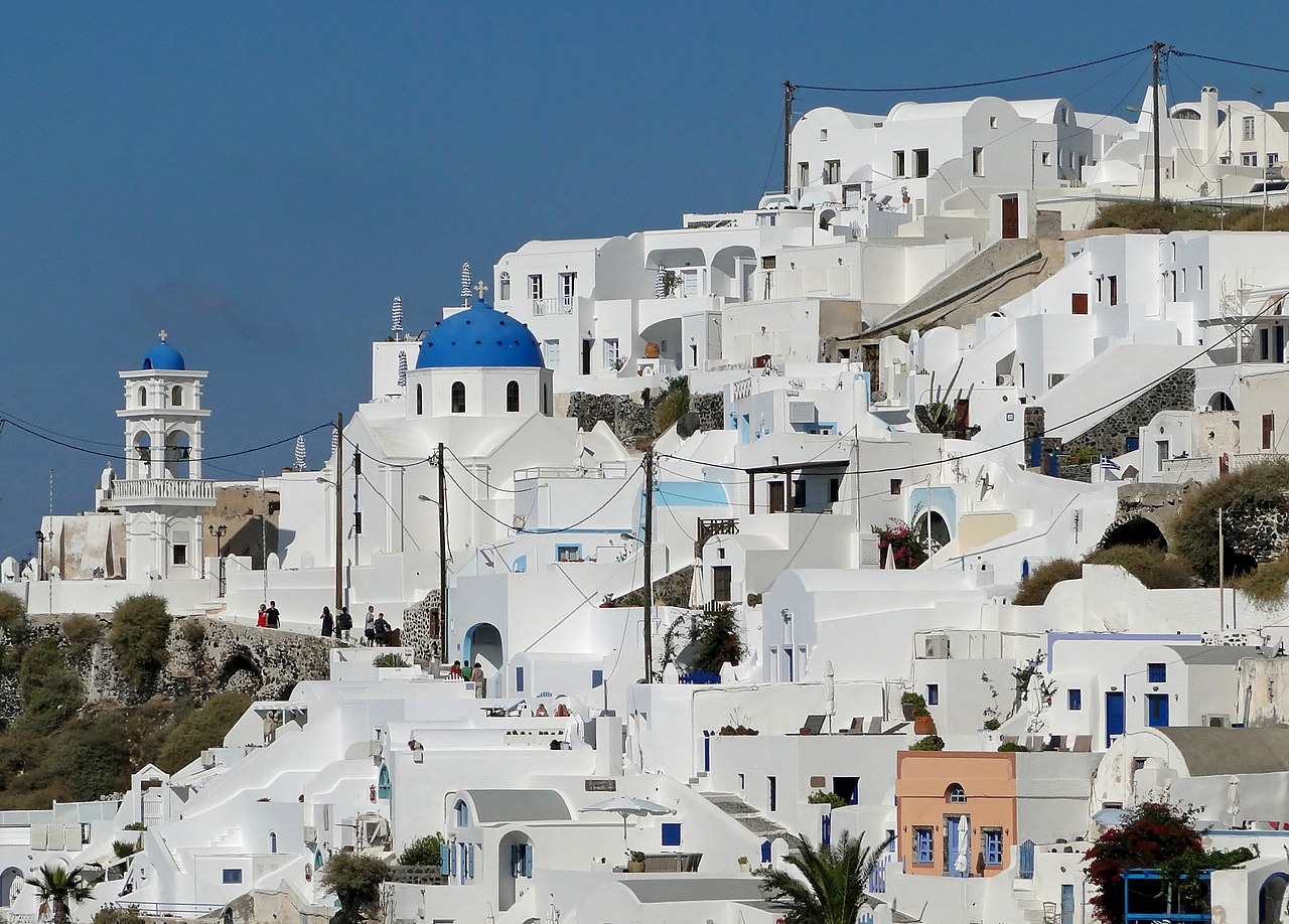
Quick answer. Yes. Mappu’s Imerovigli audio guide (Santorini, Greece) is free in your browser: 5 sections and about 5 minutes of listening, in 6 languages. It covers “A Name That Means Lookout”, “Skaros Rock and the Little Chapels” and “Blue Domes and Cycladic Lanes”. In the Mappu app, Walk Mode narrates the places around you as you move and answers your follow-up questions.
Mappu's own map of the place, with the paths and entrances OpenStreetMap shows around it.
Welcome to Imerovigli, a village on the island of Santorini in Greece, set just north of the island capital, Fira. This guide treats Imerovigli as a whole village rather than a single monument, so what you will hear is the story of the village and the landscape around it. The first thing to know is where it sits. Imerovigli is built right on the rim of the Santorini caldera, the great volcanic bowl that gives this island its drama. Narrow paved paths thread through the village, and as you walk them you are always close to the edge, with the open caldera just beside you. Over the next few minutes we will look at what the name means, at the rock and chapels that surround the village, at its churches and its Cycladic character, and at the island story behind it all. Let your feet slow down a little. This is a village that rewards a slow pace.
Start with the name, because it explains the whole place. Imerovigli comes from the Greek word vigla, which means viewpoint. Villagers once stood on this high edge and watched the sea, and from here they could see pirate ships approaching in the old days. Think of it as an early warning system built out of geography. The cliff gave height, the caldera gave distance, and the sea gave a long, open horizon. A village perched here could spot trouble well before it arrived. Today the same position works in a gentler way. People come for the view the old watchers had, and many call Imerovigli the balcony to the Aegean. When you stop at the edge and look out, you are doing exactly what the name has always asked of you.
In front of the village, an enormous rock formation called Skaros juts out toward the caldera. It is the most popular place to visit in this area, and the steps down to it are a detour of their own, off the path along the rim. Small religious landmarks stand along the way. The tiny chapel of Agios Ioannis stands on the way to the rock. The Theoskepasti chapel sits on the rock itself. Above the volcanic cliffs you will find the chapel of Agios Georgios. These chapels are modest in size, but they sit in some of the most dramatic positions imaginable, with white walls against dark volcanic stone and open sky behind them. It is a good lesson in how this island builds: small, simple, and perfectly placed.
In the heart of the village stands the Anastaseos Church, also known as the Church of the Resurrection of the Lord. It is one of the famous blue-domed churches of Santorini, with a whitewashed facade and a blue dome set against the sky. Churches here are all built in the Cycladic architectural style, which gives the village its consistent, calm look. That style is everywhere around you. Whitewashed houses sit at the cliff edge, and narrow alleys wind between them, leading you from one small surprise to the next. Imerovigli is often described as an excellent example of Cycladic architecture, and walking its lanes shows why. Take your time with the turns. Some of the best moments in the village are the hidden corners you only find by wandering, where a lane opens suddenly onto the caldera.
Imerovigli belongs to a bigger story. Santorini is a volcanic island in the Aegean, part of the Cyclades, and its map has been redrawn more than once by its volcano. The island became part of the young Greek state in 1830. Imerovigli, with Fira, Oia, Pyrgos and the others, is one of the settlements that carry that story forward. Before you move on, try this. Pause at the rim and look for the details that connect the name to the place: the long horizon the lookouts once watched, the pale chapels on the cliffs, and the dark mass of Skaros ahead of you. Then choose a lane you have not taken yet, and see where the village leads you next. There is always another corner, and another angle on the caldera.
AI-generated from 6 sources; reviewed for accuracy and last updated on October 25, 2026. Verify tickets and opening hours on the official site.
This place is stop 2 of 3 of a self-guided walk: Fira to Oia, Santorini. About 10.5 km and 140 minutes on foot, plus about 17 minutes of listening.
Indicative route. While you walk, watch where you're going, mind the traffic and follow local signs and rules. The map is an aid, not a safety guide. Terms
 Fira
about 2.5 km · about 34 min on foot

ImerovigliThis guide
about 7.9 km · about 106 min on foot
 Oia Santorini
Walk Mode, in the free Mappu app: 2 hours for 50 credits (€4.99 Starter pack)
Planning a trip to Santorini?
Mappu sketches your days free in the chat, no account needed. Then take the full plan with you:
FiraSantoriniOia SantoriniSantorini Knossos PalaceCrete
 Temple of Olympian ZeusAthens
 Acropolis MuseumAthens
 Syntagma SquareAthens
Plan your trip on a map and get an audio guide for almost any place nearby: just tap it on the Mappu map.
About 5 minutes of listening in 5 sections: “Welcome to Imerovigli”, “A Name That Means Lookout”, “Skaros Rock and the Little Chapels”, “Blue Domes and Cycladic Lanes”, and “Before You Head Off”.
Start with the name, because it explains the whole place. Imerovigli comes from the Greek word vigla, which means viewpoint. Villagers once stood on this high edge and watched the sea, and from here they could see pirate ships approaching in the old days. Think of it as an early warning system built out of geography. The cliff gave height, the caldera gave distance, and the sea gave a long, open horizon.
You can ask follow-up questions such as “How did the meaning of the name Imerovigli, a village lookout, shape the way the village was placed on the caldera rim?” and keep asking in Mappu, with the guide connected to your map and trip plan.